
15 YEARS
OF OPERATION
MILLIONS
OF ACRES FLOWN

FULL SEASON IMAGERY
BUILT FOR PRESCRIPTIONS.
While most people are thinking about their farms (or fields) in two-and-a-half-acre grids, we look at them in terms of six-inch pixels. Our imagery is an incredible scouting tool with the ability to build ultra-high resolution prescriptions. Airscout was born back in the 90s out of our founder, Brian’s, need to have accurate zones to make his precision ag equipment work with GPS. What you see today is the culmination of over thirty years of experience and learning that all started with a couple of farm kids taking pictures out of the windows of a Piper Cub. We now invite you to benefit from that experience and expertise and continue to learn with us as we persevere to be better farmers.

Why AirScout?
We are the only aerial imagery company that captures your entire field in one snap-shot. This makes every pixel relative to each other, and is the foundation to building good prescriptions. All others fly a grid pattern and stitch their imagery. This inherently creates problems making their imagery unsuitable.

Variable Rate Planting Prescriptions
This is the lowest hanging fruit, and seed savings alone can pay for an entire years subscription to AirScout.

Multi-Hybrid Prescriptions
AirScouts Thermal imagery allows you to build zones based on drought or other nemeses, so you can build defensive zones.

Scouting Emergence, Insects & Diseases
Emergence, insects, and diseases tend to follow temperatures of the soil, so you will know where to find the most troubling spots, and how much is affected.

Late Season Nitrogen Prescriptions
By combining bare soil pictures with in-season pictures, you can truly build nitrogen prescriptions tailored to your present crop.

Irrigation Prescriptions
Since thermal imagery is the first to show drought stress, it makes it a great tool to build zones for variable rate irrigation.

Yield Estimating
Our patented Yield Estimator assigns yield potential based on the thermal value of each pixel in combination with directed ground scouting, making it extremely accurate.

Fungicide or Foliar Prescriptions
Both Thermal and ADVI work in conjunction to build zones that will benefit from fungicides and foliar feeds, while leaving healthy areas potentially untouched.

Soil Sampling By Zone
Two and a half acre grids are obsolete now that you can use 6-inch pixels.

AirScout’s Seven Patents
Make us the only provider legally capable of providing these services.
OUR TECHNOLOGY
AirScout® is making a significant impact in agriculture with aerial imagery that makes a big difference in a farmer’s and agronomist’s ability to manage high-value crops more proactively than ever before. With AirScout, you see crop health alerts weeks sooner–not just days. Now you can intervene with tailored prescription treatments, created by you or your consultant, before crop yields are significantly threatened. Below are some of the highlights of AirScout’s patented technologies. The AirScout system is easy to learn, practical to use, and works seamlessly with all other precision farming technologies, including VRT equipment. This makes AirScout® The Proactive Crop Management Tool™ for farmers, agronomists, marketers, and those working in financial, regulatory, environmental, forestry, and other areas focused on the health and productivity of living plants, as well as the condition of soil and water.


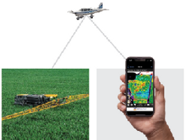
How it Works:
Airscout is a subscription service you sign up for in the spring and we capture images as soon as planting begins in your area and continue approximately every ten days throughout the growing season. A personalized “ Storybook” is generated from the images we capture and allows you to build custom in-season prescriptions and understand your end-of-season yield maps.

Product Features:

Visual
This is probably the most important image you can get, and takes you 75% of the way. The others are used to add understanding to this picture.

ADVI
This is proprietary to AirScout, and allows us to amplify shades of brown and green. It also enables us to apply numerical values to the pixels so we can build prescriptions.

Thermal
Its all about water! This image provides insight into soil moisture and plant evapotranspiration.

NDVI
This image strictly shows chlorophyll.


Nitrogen Management on a Higher Level
Empower the potential of your fields with smart & actionable information.
With HindsightN you get the power of aerial imagery from AirScout and a proven method for improved Nitrogen management that helps profitability. By analyzing the data collected from your field, we build precise prescriptions in real-time for late season Nitrogen applications. These prescriptions are strategically designed to target the higher-yielding potential zones of your field with higher N rates.

Gives your crops Nitrogen where and when it’s needed

Target higher yielding– potential zones with higher N rates

Fits within a normal Nitrogen budget and improves your bottom line

Timely & season–long images with actions impacting yields and profitability

Included in the standard AirScout® Pre-Pay

Typically lowers carbon intensity per acre
How it Works:

1. Yield Potential Map
Our fleet of aerial-survey airplanes equipped with high-resolution cameras, capture weekly images of your field up until it provides us with your “Yield Potential” map, which comes at about V8 and is the foundation of our service. *While your soil zones remain constant, your yield zones vary from year to year.


2. Mineralization Credit
The bare soil imagery tells us where the high, and low organic matter zones of your field are located. This information allows us to build you a “Mineralization Credit” map, which we’ll use to offset your need for late-season N. Our proprietary Nitrogen calculator tool makes it easy.


3. Nitrogen Prescription
We create a custom action plan for the amount of Nitrogen that is still needed and send a shape file prescription to your email or to the sprayer itself.
NITROGEN MANAGEMENT ON A HIGHER LEVEL
Empower the potential of your fields with smart & actionable information
About
AirScout is the brainchild of 5th generation Indiana farmer, pilot, and inventor, Brian Sutton. He understands the benefit of field scouting and the devastation crop disease can cause for a farm family and their operation’s profitability. Sutton noticed that when a corn crop is most vulnerable to problems, it’s also the toughest to ground scout. The intervention window is very small, and there’s no chance to replant. Launched in 2010, AirScout® leverages imagery of crops collected via fixed wing manned aircraft to build precision prescription zones and strategic scouting plans to maximize return on precision ag equipment. Sutton’s work of over a decade has resulted in a stunning breakthrough in agricultural aerial imagery, AirScout® Thermal™ Imagery.

